Keywords:
Commoning, Public Space, Knowledge Commons, Open Data, Diverse Economies, Grassroots Innovation, Urban Foraging
By Adrien Labaeye and Harald Mieg
Introduction
In times of widespread austerity measures, the self-governance of shared resources is entering the spotlight as an alternative to privatization. In the city, urban commons emerge when local public management has receded and citizens take over (Foster, 2011), or when new resources are produced by commoners (Borch and Kornberger, 2016). The breadth of urban resources analyzed as commons has rapidly expanded from parks, green spaces, and public squares to various neighborhood amenities or urban infrastructures (Dellenbaugh et al., 2015; Foster, 2011). However, for Harvey (2012), the urban commons is to be defined more broadly, such as in the intangible value of neighborhood life: the permanent production and appropriation of the urban commons by private interests being a defining feature of urbanization itself and the stake of the commoners’ struggle for their “right to the city”(Harvey, 2012).
Considering urban data as a commons is unorthodox, for “data is the new oil” [1], regarded as a resource to be extracted as a commodity for markets. Seeing urban areas as great deposits of data, and keen to benefit from a new extractive industry, IBM and its competitors re-branded some of their information systems business under the concept of “smarter” or “smart cities”, promising prosperity and sustainability through the optimization of information management (Dirks, Gurdgiev and Keeling, 2009; IBM Global Services, 2009). Commentators increasingly critique this top-down and technology-centric epistemology of the smart city vision, and call instead for alternative approaches, shifting the focus to smart citizens and their rights to the digital city (Foth, Brynskov and Ojala, 2015, vi). As we look into the tall shadow of the smart city discourse to uncover the work of (smart) citizens reclaiming their right to the digital city, the urban commons, it may be of interest to see how a commoning process may involve physical space as well as data, side by side.
By describing existing processes of commoning the city, we may better understand how the city itself may be thought of as a commons, as proposed by Foster and Iaione (2015).
The remainder of this article consists of a theory section, describing developments in the literature from urban commons to commoning, followed by a review of the literature on a particular category of intangible commons: knowledge commons. We present our adaptation of a seasoned framework to address case studies. The methods employed and considerations of collecting empirical material follow. In the results section, we present the main findings of two case studies from Berlin (Mundraub) and New York City (596 Acres). These are discussed in the context of the existing literature. Finally, we suggest further research directions and avenues for activists and local governments for the commoning of urban assets.
Theory
From urban commons to commoning the city
The first substantial theoretical discussion of commons in an urban context has to be credited to Sheila Foster (2011), who highlighted the ways in which shared urban resources such as parks, vacant land, streets, or business districts are managed by groups of users in the absence of government management and without privatization of the resource. Foster emphasizes that commons dilemmas, such as overuse or rivalry between users around an urban resource, emerge as a response to a withdrawal of public regulation in a previously highly regulated space; she calls this phenomenon “regulatory slippage”: “In simple terms, regulatory slippage refers to a marked decline in the enforcement of these standards that define the use of the resource/space in question and/or the increasing tolerance of noncompliance with these standards by users of a given public space” (Foster, 2011, p. 67). In her landmark study, Foster observes in some cities a shift from a centralized form of government to what she calls an “enabling” role of state and local governments in supporting private actors to overcome free riding and coordination problems in the collective management of urban resources (Foster, 2011). This argument is further developed in “The City as a Commons”, where the emergence of co-management of municipal services and the co-production of urban commons are the two pillars structuring an ongoing transformation of urban governance from a controlling state (the Leviathan) towards a collaborative state (the Ubuntu) (Iaione, 2016). Epitomizing this approach, the city of Bologna adopted in 2014 a “Regulation on Collaboration between Citizens and the City for the Care and Regeneration of Urban Commons”. In this enabling role, the government may ensure that formal agreements for cooperative management of public resources are time-limited, in order to reduce the risk of ossification, a process whereby commons institutions become static and rigid in the face of a changing environment (Foster, 2011, pp. 130–132).
A handful of other authors have thematized commons in the urban context: as an alternative to privatization in a context of budgetary austerity (Stelle Garnett, 2011), as a key resource in building resilience in cities (Colding and Barthel, 2013), or as the result of the civic activation of public space (Radywyl and Biggs, 2013). De facto, the academic discussion about urban commons has focused almost exclusively on tangible resources. A notable exception is Foster and Iaione (2015), who take into account the existence of intangible (e.g., sense of safety or social networks) or digital (e.g., data or infrastructure) goods as urban commons. This is reflected in their significant contribution to shaping the City of Bologna regulation (2014). This intangibility of the commons is evident in David Harvey’s analysis (2012), where he describes the urban commons as the co-created value of a neighborhood, and the commoners’ struggle to protect it from private appropriation as the cornerstone of citizens’ rights to the city. Harvey recognizes a “social practice of commoning” established between a social group and an aspect of its environment considered as a commons (Harvey, 2012, p. 73). Similarly, commoning is also used to describe the resistance to enclosure, the opening of new commons (Dwinell and Olivera, 2014), or the process whereby a community reclaims an urban resource as a commons (Sundaresan, 2011).
A more anthropological and historical strand of the literature also switches to the verb form “commoning”, giving more room to the changing nature of urban commons (Linebaugh, 2008). Thus, for Bresnihan (2016), commoning emphasizes the fluid, continuous nature of the production of urban commons understood beyond the “objective limits” of a static, physical resource, but also integrating people, physical space, materials, technologies, and knowledge. Here, the commoning process inherently extends beyond the tangible resource.
Knowledge commons: The IAD framework
Commons have often been analyzed through the Institutional Analysis and Development (IAD) framework, which has mostly been applied to the governance of rural tangible resources such as forests, fisheries, or irrigation systems (Ostrom, 1990). More recently, it has also been successfully extended to intangible resources such as open-source software (Schweik and English, 2013), online creation communities (Fuster Morell, 2014), and genomic data (van Overwalle, 2014). Indeed, as Christine Hess and Elinor Ostrom argue:
“[The IAD] framework seems well-suited for analysis of resources where new technologies are developing at an extremely rapid pace. New information technologies have redefined knowledge communities; have juggled the traditional world of information users and information providers; have made obsolete many of the existing norms, rules, and laws; and have led to unpredicted outcomes. Institutional change is occurring at every level of the knowledge commons.” (Hess and Ostrom, 2007, p. 43)
The most prominent adaptation of the IAD to knowledge/information commons is to be credited to Madison, Frischmann et al. (Madison, Frischmann and Strandburg, 2010). They define constructed commons in the cultural environment (in contrast to the natural environment) as “environments for developing and distributing cultural and scientific knowledge through institutions that support pooling and sharing that knowledge in a managed way” (Madison, Frischmann and Strandburg, 2010, p. 659). In a more recent definition, Frischmann, Madison et al. (2014, p. 3) adopt the terminology “knowledge commons”, defined as “shorthand for the institutionalized community governance of the sharing and, in some cases, creation, of information, science, knowledge, data, and other types of intellectual and cultural resources.” In this article, to avoid ambiguity, we prefer to speak of a commoning process to describe this community governance, and reserve the use of “commons” to describe the shared resource as is often the case in the literature (Hess and Ostrom, 2007, p. 3).
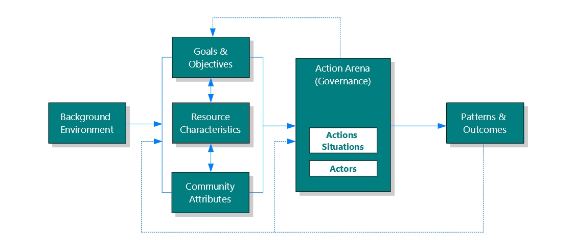
Figure 1: The IAD framework for knowledge commons. After Frischmann, Madison et al. (2014)
In the present study, we use our own adaptation of the IAD framework for knowledge commons (Figure 1) in its most recent version by Frischmann, Madison et al. (2014). In this framework, a Background Environment is seen as a given in the study of a knowledge commons. It influences a set of Attributes that are interconnected: Goals and Objectives, Resource Characteristics, Community attributes. These define the governance (and possibly production) of the commons — the Action Arena in which actors interact through various Action Situations. This results in the emergence of Patterns of interaction that may solidify over time and generate Outcomes such as the creation, expansion, or degradation of a new or existing knowledge commons. In a feedback loop, these Outcomes will in turn redefine the initial set of attributes or, more directly, influence the structure of the Action Arena, with for example the emergence of new Patterns of Interaction creating new Action Situations. An apparent difficulty, in applying the IAD for knowledge commons to our hybrid cases characterized by the presence of both tangible and intangible resources, lies in the fact that the framework has previously been adapted by Frischmann et al. (2014) through two main modifications intended to fit intangible resources (knowledge).
- The resource does not predate the community, but is produced as the community develops (a fundamental difference from natural commons Frischmann, Madison and Strandburg, 2014, p. 19 that explains the interconnection between Attributes).
- In the production of a knowledge resource, the “Patterns of Interaction” — the interaction of people with the resource and one another — are themselves an intended “Outcome” and inextricably linked with the knowledge output of the commoning process (Frischmann, Madison and Strandburg, 2014, p. 19).
In the urban environment, tangible resources may predate the emergence of a community of users, but may not be in use and thus not perceived as a resource (e.g., vacant land). Thus, analyzing the commoning rather than the commons, i.e., the process by which existing resources are reclaimed and used as commons, may actually benefit from these adaptations, as they emphasize the dynamic character of the process.
Moreover, Frischmann, Madison et al. (Schweik and English, 2013, p. 238). Emphasizing this aspect, Fuster (2014) argues that infrastructure provision (in our case studies, the provision of an online mapping platform) is not neutral for online creation communities and should therefore be integrated into the Governance process (Action Arena) rather than forming part of the Resource Characteristics as in Schweik and English (2013). This provides a theoretical avenue for extending our understanding of the provision of a participation infrastructure beyond the digital realm, taking into account the changing role of the local state that would traditionally manage a highly regulated urban space (Foster, 2011).
Research questions
In this article we use the IAD as refined by Frischmann, Madison et al. (2014) to elucidate the main interrogation: How does the hybrid commoning process of (1) data and the related (2) public space take place? In particular, we seek to understand the role of the participation infrastructure providers (mainly grassroots initiatives) in the creation of a community of users that is both a pattern of interaction in and an outcome of the commoning process.
Materials and methods
We chose a case study approach, as this has been widely used to analyze commons (Poteete, Janssen and Ostrom, 2010). Case study research is seen as particularly appropriate for explorative and evaluative research, and supports conceptual refinement and theory-development (Poteete, Janssen and Ostrom, 2010, pp. 34–35) as in the present study. The description of such (rather hidden) phenomena may also make them more real and credible to policy and activism, making the research itself a performative ontological intervention (Gibson-Graham, 2008).
The two case studies were chosen for their similarities. In both cases, data about the urban space (vacant lots and growing edibles) is being collaboratively produced or reclaimed, and refined into an open and shared resource by a citizens’ initiative — a knowledge commons (Frischmann, Madison and Strandburg, 2014; Fuster, 2014; Hess and Ostrom, 2007). Yet, for both initiatives, that intangible commons is only a means towards an end; by being made actionable through the use of a mapping platform and further actions including community building, it results in a new, collective form of public land use: urban foraging on the one hand (Berlin); community spaces such as gardens on the other hand (NYC). What used to be neglected public assets — fruit trees and wasteland — are turned into shared resources that provide opportunities for community activities, reconnection to nature, food production, and DIY practices.
To structure our study we rely on an IAD framework for knowledge commons adapted for hybrid urban commoning processes that combine an intangible and a tangible resource. Table 1 presents a condensed version of the framework, including representative and operational research questions proposed by Frischmann, Madison et al. (2014) and completed with Fuster’s (2014) focus on infrastructure provision (in Governance).
| Representative research questions to apply simultaneously to the intangible and tangible dimensions of the commoning process: (1) about and around data; (2) about and around vacant public land and growing edibles |
| Background Environment |
| What is the background context (legal, cultural, etc.) of this particular commoning process and the default status of the resource involved (patented, copyrighted, open, or other)? |
| Attributes |
| Goals and Objectives |
| What are the goals and objectives of the commons and its members, including obstacles or dilemmas to be overcome? |
| What are the history and narrative of the commons? |
| Resource Characteristics |
| What resources are pooled and how are they created or obtained? What are the characteristics of the resources? Are they rival or nonrival, tangible or intangible? Is there shared infrastructure? |
| What technologies and skills are needed to create, obtain, maintain, and use the resources? |
| Community Attributes |
| Who are the community members and what are their roles? What are the degree and nature of openness with respect to each type of community member and the general public? |
| Governance |
| How is the participation infrastructure provided? Who has a say in its development? Does it allow horizontal organizing (i.e., without control/facilitation from the infrastructure provider)? Is the design of the infrastructure open? (added after Fuster, 2014) |
| What are the relevant action arenas; how do they relate to the goals and objective of the commons, and the relationships among various types of participants, and with the general public? |
| What are the governance mechanisms? Who are the decision makers and how are they selected? What are the institutions and technological infrastructures that structure and govern decision making? • What informal norms govern the commons? |
| How do non-members interact with the commons? What institutions govern those interactions? What legal structures (e.g., intellectual property, subsidy, contract, licensing, tax, antitrust) apply? |
| Patterns of Interaction and Outcomes |
| What benefits are delivered to members and to others (e.g., innovations and creative output, production, sharing, dissemination to a broader audience, and social interactions that emerge from the commons)? |
| What costs and risks are associated with the commons, including any negative externalities? |
Table 1: Proposed operational framework for hybrid urban commons. Adapted from (Frischmann, Madison and Strandburg, 2014)
The case study data were collected between 2014 and the beginning of 2017. Data collection was conducted in the form of participatory observation, both online and onland. We crafted the neologism “onland” to reflect the fact that even when the action is situated in the physical space it is not necessarily offline: people increasingly using mobile Internet access, blurring the line between offline and online [2]. We gathered primary data through single, semi-structured interviews with one founding member of each initiative, a key executive member of a relevant local administration in each city, and three participants in Berlin (seven formal interviews in total). Interviews in NYC were conducted via VoIP (i.e., Skype). This was completed by extensive online documentary research facilitated by the vast digital self-documentation of the initiatives: blog posts, articles by the initiative in publications or conferences, third-party publications (press and grassroots blogs), etc. In addition, our research objects include the online platforms themselves, which we used to gain first-hand knowledge of the online collaborative process. We were thereby able to observe how the platforms evolved over approximately three years, and to make direct use of the data they provided (e.g., number of NYC administrative agencies having ownership of land).
Results
Mundraub, Berlin
Background environment
While existing cadasters of trees situated in public space are maintained by borough administrations and theoretically accessible to the public upon request (“we have no secret to hide” says a Berlin administration executive [3]), they are in practice and historically not freely accessible. The reasons advanced by public actors range from liability issues or economic argumentation to technical difficulty: “I guess [citizens] do not have the proper software” says the same administrator [4]. The status quo in the physical space is that citizens are required to file a request to their borough’s administration to forage from public trees, while pruning remains the exclusive domain of municipal employees or subcontractors. In practice, most foragers (with the exception of schools) generally ignore, willingly or not, the need to secure authorization for harvesting fruits, and borough administrations seem to show no particular concern about enforcing this: i.e., there is regulatory slippage. Generally, fruit trees have comparatively high maintenance costs and are therefore not a favored option by a financially-constrained municipality. Starting in 2011, a neighborhood group (unrelated to Mundraub) in collaboration with the Berlin-Kreuzberg borough administration successfully planted a relatively large number of fruit trees in Görlitzer Park, one of the most popular parks in the city.[5]
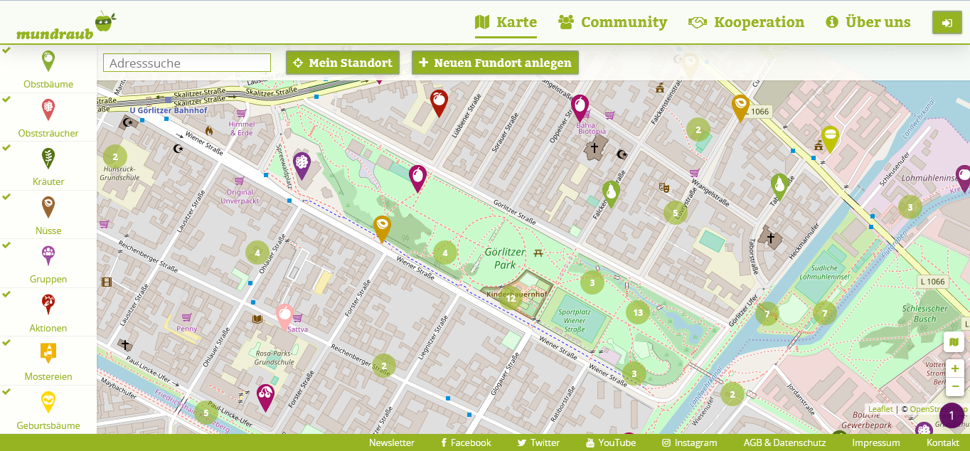
Figure 2: Map screenshot from http://mundraub.org. Clustered points of interest split into individual points when zooming in.
Goals and objectives
Mundraub started in Berlin in 2009 from an individual initiative. Shown in Figure 2, its main product is a collaborative map platform that crowdsources and visualizes the locations of most common types of fruit trees and bushes in German-speaking countries. Each tree or group of trees is marked by a point of interest (PoI) that can be reviewed, complemented with pictures and descriptions. Although apple picking for cold-pressing juice is a relatively common practice nationally (nabu.de, no date), urban foraging was a very hidden practice before the launch of Mundraub. The motivation for co-producing a data commons in the form of a collaborative map is to enable people “to discover the secret fruits in public space and [eventually] to collectively shape the edible landscape” (mundraub.org, no date) through the practice of (urban) foraging. The constitution of a data commons, that substitutes for inaccessible and incomplete public data, is not separate from the wider process of commoning the edible landscape. On the contrary, it is seen by the Mundraub initiative as a constitutive tool of one wider process of public re-appropriation. One central dilemma is to create a sense of responsibility and to spark collective action among people who are first reached through the Internet — a medium that favors anonymity and individualism. That same anonymity and the impossibility of effective control are also to be found in the urban public space in which the edibles are situated. Such scenarios often invoke the free rider dilemma, as illustrated in the words of a Berlin urban forager:
“I would be worried to add [on the map] trees growing in the neighborhood. Trees with some tasty fruits, and I add them and they are immediately fully harvested. […] I also think there should be something left for birds and so on. I am not sure that people share this kind of notion.”[6]
Historically, trees and greenery in cities are only valued for their esthetic value, and managed accordingly, top-down, by the municipal administration. Mundraub’s narrative is to bring awareness to citizens about urban nature by re-conceptualizing it as an edible resource with which they can directly engage through harvesting, care, and further planting.
Resource characteristics
However, the respective commoning of data and the related physical urban space are facing different types of challenges due to the differing nature of the resources in question: nonrival and intangible for data, versus rival and tangible for edibles. The intangible resource is constantly expanding, with an ever-growing number of people adding new points and reviewing existing ones. Since 2016, municipal data are also slowly being added as a result of Mundraub and its wider community advocating for local governments to open their tree cadasters. While such data are still marginal, this process of data release is very likely to increase significantly in 2017 and 2018 as the initiative concretizes long-term lobbying efforts and further adapts its online infrastructure to facilitate data imports. The development and maintenance of this collaborative mapping infrastructure is made possible by in-house and subcontractor programming skills organized by the Mundraub initiative. Consulting and contributing to the map itself was made very easy, and it is accessible to most Internet users with basic digital literacy. Similarly, harvesting well-known edibles generally requires little skill. However, identifying more unusual edibles such as wild fruits or herbs is not accessible to everyone, and the map may therefore be a precious tool for finding such when images are available. Some basic knowledge of handling trees with care is also critical to ensure that foragers do not damage a resource that regenerates very slowly. Indeed, Berlin boroughs plant few edible trees as these require greater maintenance that cannot be afforded under severe budgetary constraints. Thus, in December 2016, and in collaboration with the Berlin-Pankow borough, Mundraub crowdfunded the planting of twelve fruit trees in a public park. A similar action on the private land of a supermarket led to the planting of five trees. Both actions are pilot projects in a testing phase that may result in more planting, both in Berlin and beyond, and which raises a question: Will people continue to take care of trees from which fruits may be harvested by anyone?
Community attributes
The small staff (3 to 5 employees) of the Mundraub initiative are formally employed by the non-profit enterprise (gUG in German) Terra Concordia. It plays a key role as infrastructure provider, maintaining and developing the online portal built around the map. Staff members also dedicate a considerable amount of their time to engaging throughout Germany with municipalities and citizens to propagate the practice of urban foraging and its acceptance among local governments. Anyone can take part in Mundraub, and, a fortiori, in urban foraging. Online, anyone can consult the map, although visitors need to register in order to contribute to it or to access online discussion groups. As of October 2017, almost 60,000 people have registered (almost doubling in two years), and many more have consulted the map (however, traffic statistics are not available). Onland, and in practice, anyone can forage even if it formally requires municipal authorization. Generally, we observed difficulty in building a real, lasting community of urban foragers, be that online or onland. Activity on the platform’s forum is low, and is limited on a self-organized Facebook group where Mundraub only engages in minimal so-called community management. Onland, two types of action seek to build a community. On the one hand, a handful of community organizers, who may be professionals or volunteers, are organizing community actions such as foraging tours to learn more about urban edibles or to press apples together. On the other hand, tree sponsoring is possible since the end of 2016, for anyone willing to make a donation (around 100 euros) and commit to caring for the tree in its initial years. Tree sponsors are encouraged to collectively organize, to plant and ensure good care for the tree.
Governance
The development of the online plarorm itself gives little room for users’ involvement. There is actually very little demand for that, which may result from an online experience in which interaction with other users is very limited. Specific demands, however, are implemented punctually, as in the case of the switch from Google Maps as a base layer to OpenStreetMap, a map commons. The code for the platform is not open source, since Mundraub views this as an asset of the organization — not of the community. Similarly, the data (while freely visible online) are copyrighted and not reusable. Researchers are usually granted access to the raw data. The Mundraub leadership considers that it has a responsibility to ensure the data are in good hands and taken care of: “contributors provided the data to us, on our website, they have entrusted us with it [7] and [we] are liable for that.” Rules regarding the way in which data are contributed and then managed are defined — unilaterally — in the website’s Terms of Use by the infrastructure provider, which has exclusive privilege over rectifying, editing, and deleting data. Nevertheless, when users flag inaccurate or inappropriate data, the complaint is first sent to the initial contributor who is given an opportunity to rectify it: “the community has grown so strongly that it is checking almost on its own [the compliance of data]” says a Mundraub staff member [8]. Beyond that, users are not involved in the governance of the online infrastructure and data: We cannot observe any arena for such actions, apart from the editing of individual points. It seems that all actors involved view this only as a tool for the commoning of the physical resource (where the real action arena is). It is really in the interaction of Mundraub and other grassroots actors with the administrations and local governments of Berlin boroughs that the main action arena is situated, particularly in Berlin-Pankow where the first policy outcomes were observed. In the shadow of these formal contacts, the everyday practice of urban foraging in public space is a more diffuse action arena, where a slow transformation in the way the public relates to the urban landscape may be observed but hardly measured. The emergence of rival use is answered by a set of voluntary rules published by Mundraub, although lacking verifiable impact. The general governance of urban space is very rigid, as many vital urban interests such as transportation take precedent over most other priorities: thus, trees allowed along streets have to fulfil very strict criteria to cause no perturbation to traffic. In dedicated green spaces, that governance is more flexible but still complex, with multi-layered rules (e.g., heritage regulations) specifying the nature and function of greenery. Ultimately, no exclusive rights are granted to foragers over edibles that remain open access. Within the framework of the planting pilot project in Berlin-Pankow, the right to prune the trees has been extended to anyone willing to do so. It is up to citizens, supported by the Mundraub initiative, to self-organize to ensure this is done properly and promptly. Generally, the practice of urban foraging disrupts the established norm by making it normal for foragers to harvest fruits and take care of edibles, in contrast to a previous perception of urban greenery as mostly ornamental.
Patterns of interactions and outcomes
The results of the data commoning are an unmatched knowledge resource about growing edibles in public space across Germany and in particular in Berlin. Through its map, it communicates an alternative (visual) representation of the urban landscape as an edible space. The map also draws attention to related events that may result in face-to-face encounters. The cost of such a commons lies in providing the infrastructure (programming hours, server hosting, community facilitation). A potential risk (although highly theoretical) is that municipalities might stop tracking the status of their trees in order to save financial resources and ultimately rely on a platform that lacks stable funding sources. When it comes to the commoning of the physical resource, the level of interaction (and its variation) of urban dwellers with the edible landscape is difficult to estimate, as it occurs in the anonymity of public space. The formal governance of edibles remains unchanged in Berlin, apart from Berlin-Pankow where a clear change has happened: The city has allowed by default all citizens to forage without having to file a request, and it is testing the delegation of planting and caring for new edible trees to citizens through the mediation of Mundraub. If successful, the municipality, Mundraub, and other grassroots actors hope to be able to expand the presence of edibles in the urban landscape within the context of severely restricted local government resources. The prudence shown by the local administration is attributed, by a city executive, to the perceived risk that citizens’ involvement would not last beyond the initial hype, and that newly planted fruit trees would therefore become a financial burden for the city [9]. Nevertheless, the same executive formulated another positive effect of the commoning process as: “[citizens] switch from being like passive customers who just expect something in return for the taxes they pay, to a more active and civic attitude where they feel and act responsibly” [10], which could have positive effects on associated issues such as littering, for example. However, we did not observe any direct synergies with another significant planting project in a different borough, which questions the capacity of Mundraub to embed its action within the existing grassroots networks.
596 Acres, New York City
Background environment
Under New York State’s Freedom of Information Law (FOIL), local government has a general obligation to provide citizens access to any public information (excluding special exemptions). Despite this legislation, until 2013 the New York City (NYC) land database (PLUTO) was only accessible by payment of a $1,500 fee for a semester update. In 2013, the 596 Acres initiative submitted a successful FOIL request to access that data free of charge. Shortly after, the database was released as open data through the city’s dedicated portal. Onland, the traditionally large amount of vacant land in NYC is the result of the city’s fiscal crisis in the late 1970s, resulting in the historical widespread development of community and intercultural gardening, with more than 500 gardens across the city. However, vacant land is now becoming scarce. Remaining vacant public land is often fenced and in a wasteland condition, generally awaiting development by one of the 23 agencies or departments that might own it.
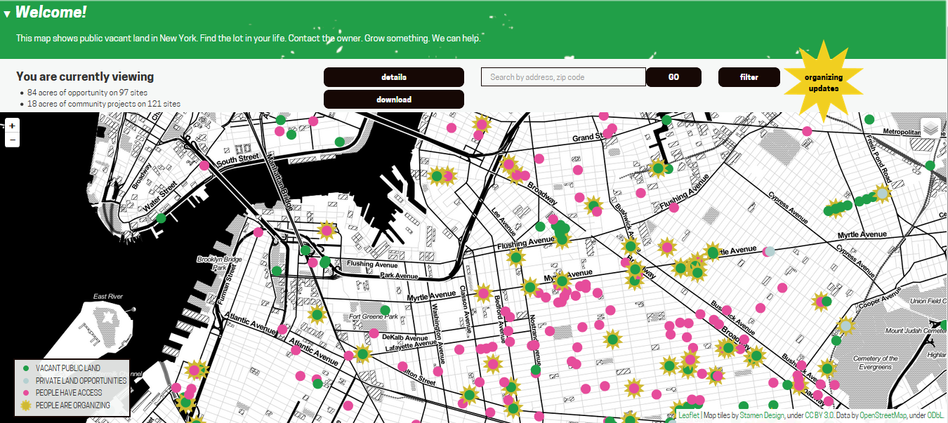
Figure 3: Screenshot of http://Livinglotsnyc.org. Points of interest turn into surfaces when zooming in.
Goals and objectives
The main goal of the 596 Acres initiative is to promote community land access in under-privileged neighborhood by reclaiming vacant land. To realize that vision, an intermediary objective has been the development and maintenance of a comprehensive database of vacant land, including information on ownership, in the form of a participative map (see the Living Lots Map [11] in Figure 3) where people can get in touch with each other and get organized around each PoI (i.e., each vacant lot). The map key distinguishes between vacant public and private land, lots already in the hands of communities, and lots where communities are organizing. The dilemma is to ensure the comprehensiveness and ‘freshness’ of data, but also its translation into accessible information for a population that is not necessarily digitally literate. The 596 Acres narrative claims that when this enclosed data are made accessible and actionable, this can help local communities regain control of public land in their neighborhood. The main challenge involves encouraging people to self-organize in order to obtain the right to manage a piece of vacant land, and to actually turn it into a functioning and sustainable community space (often a community garden). Overall, the narrative of 596 Acres is that collective access to land “spurs bottom-up development that compensates for uneven growth” (596acres.org, no date) in a city where gentrification is profoundly reshaping the urban landscape and sociology.
Resource characteristics
The data resource is intangible and nonrival. It is derived from open data, completed by the 596 Acres staff, and enriched by the crowd when it is networking online. The online participation infrastructure is provided by 596 Acres in the form of a collaborative map designed to enable direct contact between users and that requires only basic digital literacy. The provision of this infrastructure requires programming skills brought by one of the three members of staff. At the physical level, vacant land is a legacy resource, tangible, and rival. Land values have rocketed in recent years, being highly coveted for private real estate development but also for so-called affordable housing development by the NYC Department of Housing. Gaining access to a vacant lot requires an understanding of municipal rules and procedures. Good social and organizational skills are required to successfully organize a community space (such as an open garden). On both those fronts, citizens can find support through 596 Acres and other actors. Community attributes Online, users of the Living Lots map can review data and interact with each other around a given lot — 1882 had done so as of April 2017. Those discussions are visible to any online visitor. 596 Acres’ staff provide the online participative mapping platform, curate the open data from various data sets (including updates), and facilitate online participation. Foremost, the staff also activate and support volunteers onland who are willing to set up and self-organize a community space on vacant land. However, speaking of a community around 596 Acres is challengeable. Thus, in the words of one of the founders, “I think this is much more of a network than anything; we do try to feed people into existing communities. There is community garden community in New York that is pretty strong.” [12]
Under an agreement with the Department of Parks and Recreation (DPR), most existing community spaces have to guarantee the general public (such as non-participating neighbors) access for at least 20 hours per week during the warm season. Beyond this minimum, each self-organized group is free to restrict and regulate access to the space it manages.
Governance
The local users do not participate in the development process of the participation platform itself (reportedly, there is no demand for it). Nonetheless, the platform employs open source code making it available on a public repository, which is understood as a commons and has been replicated in other cities through partnerships between 596 Acres and other initiatives. Legally, 596 Acres Inc., the infrastructure provider, is a corporation fiscally funded by the non-profit Fund for the City of New York. Online, rules are defined unilaterally by 596 Acres. Users may flag irregular entries, but ultimately the provider has sole power to edit entries according to the website’s Terms of Use. Online, the focus of the action arena resides in the disclosure and visualization of data that were previously not open. This later shifted to the meshing of the initial data sets with additional data sets, and the translation of data into simple and actionable information on vacant pieces of land, then directly reaching neighbors whom an online map would likely miss. Overall, there is little actual crowdsourcing of data, and because the Living Lots map data are the result of combining various data sets they are not actually licensed.
Onland, three foci of a larger action arena reaching beyond the sole 596 Acres’ activities can be observed. One is around the process of a citizens’ group gaining rights to use a vacant lot and formalizing these under an agreement with the relevant municipal department or agency. This may require local coalition-building and advocacy. Another focus is when an existing community space is threatened by a decision of a municipal department. In such cases, intense advocacy takes place and, if successful, may lead to the transfer of the land lot from a department to the DPR to preserve its existence. This happened in 2016, when more than 10 lots occupied by community gardens were transferred from the Department of Housing to the DPR. The last focus of the action arena is the internal level, of self-organizing a community space. Groups have to design their own rules to ensure respect for the formal agreements, to balance diverging interests between members, and to welcome the external public. When under agreement with the DPR, repeated violation of terms may theoretically lead to the dissolution of the space. However, the municipal approach is rather supportive, in particular through Green Thumb, its community gardening program that provides community support, tools, and other gardening materials. Green Thumb oversees the management of more than 500 community gardens across the city without taking part in their governance. While vacant lots are usually fenced and accumulate garbage, community spaces are generally well curated by self-organized groups where the norm is geared towards inclusiveness, openness, and co-production.
Patterns of interaction and outcomes
The commoning of data on vacant land ownership in the form of a map resulted in a comprehensive and open information resource where previously there was only an expensive database used by those who could afford access. This is very valuable for citizens in need of such information, and even sometimes for members of municipal departments who enjoy its accessibility. The networking component of the online platform also enabled active neighbors to meet each other, thereby stimulating the commoning of vacant land. However, it is really the footwork of 596 Acres, based on its treasure trove of information and also benefiting from a supportive municipal and grassroots context for community gardening, that resulted in the creation of 36 community spaces on former vacant lots, which further strengthens the local sense of community. Community gardens also provide a source of fresh food, although in limited quantity. The costs of community spaces are borne by self-organized groups that volunteer their work and fundraise the resources they need, thereby imposing no burden on municipal finances. However, municipal departments may object to making their vacant land available, on the basis that it has been set aside for future developments that are more financially interesting than community spaces operated by groups who may be unwilling to return the land after temporary use (risk of ossification). The constitution of the online platform and its maintenance was funded through a series of grants and donations.
Comparative remarks and framework evaluation
Both in Berlin and New York, the commoning of data/information resources through a mapping interface functions only as a tool for the commoning of the physical urban space. It is important to note that neither of these local initiatives emphasizes the involvement of their platform users in the governance of the intangible resource (data and platform), as this is not in demand (aside from punctually responding to specific requests). In practice, both initiatives focus all their efforts towards engaging people in making use of the platform and data, contributing to it, and especially towards converting online interactions into action in the physical space — i.e., building an active community of participants. However, 596 Acres seems keener to mesh its activities with the existing grassroots networks of local community gardening, delivering somewhat greater local relevance. It should also be noted that Mundraub promotes a practice (foraging) that has no established community either in Berlin or Germany, and that the group’s activities also have a significantly more national profile. The latter may well explain that for Mundraub the continuous expansion of a mostly crowdsourced data commons remains an important goal for scaling the practice and extend the community beyond its first locations of adoption. Conversely, relying mostly on open data and focusing its development within NYC (leaving replication in other cities to external partnerships), 596 Acres reached the peak of its data commoning in the first years of operation and then refocused its efforts on footwork towards community-building.
However, in both cases, the main action arena is situated around the use of the public physical space: Where can a group plant trees? Can a group be granted the use of a vacant lot? What rules apply in a community space? The digital dimension of the two commoning processes observed in Berlin and NYC is more of a strategic one, where only the initiatives as organizations (not the participants) are really agents. In contrast, the closer that issues are to everyday practice (foraging, community gardening), the more participants become agents — defending interests, negotiating rules, devising solutions, etc. The addition to Frischmann et al. (2014) of an element addressing the issue of infrastructure provision (Fuster, 2014) proves useful as it opens the door to understanding the city itself as an infrastructure; local government transitioning from a Leviathan form of management to a more enabling/collaborative actor. This happens cautiously in Berlin, with a longer track record in New York City:
“With increasing participation of the public, the role of city administrators in charge of public land is changing from being simple managers of streets and park to becoming more facilitators, coordinators.” An administration leader, Berlin.[13]
“We want to make sure those gardens are stable. But we don’t intervene in any decision-making, we provide them with templates sometimes. […] What we ask them is to have by-laws or some guidelines, regulations on how they manage the garden. […] Sometimes, when there are conflicts with neighbors for example we facilitate the process, but generally we try to stay away, giving them the tools to resolve the conflict themselves.” An administration leader, New York City.[14]
Discussion
While regulatory slippage was identified in the early literature as a frequent factor behind the emergence of urban commons, proactive bottom-up initiatives may engage the local state in reframing its role towards a more collaborative attitude supportive of commoning processes. Commoning data may then be used as a trigger for a wider process. In the second part of the discussion, we reconsider the nature of commoning — from describing it as a process to seeing it as a practice.
From regulatory slippage to the collaborative state: Data commoning as a trigger
Foster explains the emergence of commons dilemmas (i.e., the commoning of urban resources) through regulatory slippage resulting in an absence of government management (Foster, 2011). While partly confirming this hypothesis, our results have shown that commoning may also emerge as the result of strategic interventions (i.e., providing actionable information about a tangible resource) that redefine the nature of urban resources (e.g., a fenced vacant lot) that were less subject to receding public management, than they displayed unexploited potential to entrepreneurial citizens. Thus, the activation of public space may radically change its function and nature through the emergence of commoning initiatives (Radywyl and Biggs, 2013). This has been shown in notable empirical examples of self-organized WiFi networks in Spain [15] and Germany [16] that gave rise to a new urban commons: free Internet access. Generally, the local state may play a critical role (as participation infrastructure provider) in enabling collaborative management of urban resources, as shown in other cities such as Bologna (Foster and Iaione, 2015). This trend towards municipalities as a local emanation of the collaborative state (Foster and Iaione, 2015) is linked to a phenomenon uncovered in our cases studies.
Confirming the idea that open data makes government more porous (Bollier, 2016, p. 16), our results have shown exactly that: When data are available and made actionable for the lay citizen, this can function as a trigger for commoning practices that do not fit within traditional government categories. Based on our findings, the further replication of such synergy may require three things. Firstly, that local governments make their data available in accordance with good practice principles: This is an ongoing trend embodied by the open data movement, resulting in the public release of thousands of municipal data sets globally, as shown by the Global Open Data Index survey (Open Knowledge, no date). When initiatives rely on crowdsourcing data, the fact that no particular equipment is required to collect data greatly helps adoption. Secondly, it requires the existence of civic actors (grassroots organizations, hackers, social/civic entrepreneurs) that have the skills and organizational capacity to shape raw data into constantly evolving information product(s) — such as dedicated mappings — that remain actionable in the context of a living commoning practice, performing a political discourse about the city as seen in other initiatives such as the Smart Citizen Kit [17]. Thirdly, our cases demonstrate that greater impact in the city is achieved through the activation of local communities; online mapping, as performative as it is, remains a trigger and requires onland action to realize its full potential in commoning the city. With those three conditions it seems that cities may well “find data-driven ways to embrace the power, flexibility and conviviality of the informal economy” (Bollier, 2016, p. 18).
Beyond the IAD framework: Departing from a naturalist conception of the commons
In framing the case study findings, our adaptation of the IAD framework is helpful in emphasizing the dilemmas and challenges specific to different types of resources, but it raises three issues. Firstly, it creates artificial boundaries between intangible and tangible commons, online and offline communities, whereas in practice there is only one process of community building and collective action deploying itself onland. Secondly, it linearizes an organic process in which accidents, opportunities, and idiosyncrasies play a central role. Thirdly, the framework does not explain the central challenge of building a lasting local community. Indeed, it over-emphasizes the process around the constitution of a data commons that in practice involves very few actors and is simply a strategic trigger for a more complex onland process.
Our critical evaluation of the IAD (see Results) finds resonance in the literature on commoning and urban commons. Thus, for Bresnihan (2016, p. 94), “While the distinction between the material/natural commons and the immaterial/social commons can be analytically helpful it tends to be over-stated, obscuring the continuity and inseparability of the material and the immaterial, the natural and the social.” That tension is particularly well revealed in our cases, where commoning practices so obviously blend together the commoning of intangible and tangible resources. It is argued that focusing on resources and a connected process tends to ‘naturalize’ a reality that is largely social and complex (Bresnihan, 2016, p. 93). This critique of a naturalist understanding of the commons transported by Ostrom’s epistemology finds its source among feminist scholars (Federici, 2001; Shiva, 2010) and geographers (Blomley, 2008; St. Martin, 2009) for whom the commons was never a resource. Commoning — the verb form emphasizing the shift away from an ontological divide between object and subject (Bresnihan, 2016) — is a living process (Bollier and Helfrich, 2015), or more accurately a social practice (Harvey, 2012): “the commons […] is only ever constituted through acting and doing in common.” (Bresnihan, 2016, p. 96). Such an ontological shift towards representing commoning as a practice is necessary to perform an ontology of the city in which smart citizens, not the smart city, are the subjects.
This is not just a rhetorical argument. Conceptually separating data from the various realities (physical, social, etc.) in which it is embedded is largely performative of a narrow neoclassical vision of the urban (economy) that eludes, for instance, questions of power in the engineering of information systems. To that extent, using the IAD framework slightly contradicts our intention to position the present research as a performative ontological intervention of documenting an alternative urban reality (Gibson-Graham, 2008, p. 614). We are left with, on the one hand, a framework that shows analytical power in substantiating the materiality of commoning the city and, on the other hand, its epistemological shortcomings. In that context, we argue, that a shift towards documenting the practice of urban commoning while integrating analytical elements of the IAD is meaningful. In that respect, two theoretical backgrounds can be envisaged. Institutional Work is rooted like the IAD in Institutional Studies and is a perspective that seeks to uncover the internal life of processes by documenting practices: i.e., the work of actors shaping, creating, maintaining, and disrupting institutions (Lawrence and Suddaby, 2006, p. 216). While it may be a good counterbalance to IAD’s focus on process, it is rooted in the same epistemological tradition. In contrast, the endeavor of Bollier and Helfrich (2015) to use the concept of Christopher Alexander’s pattern language (1977) to capture the principles and inner dynamics of self-organization that are left unaddressed by the IAD framework allows for an epistemological rupture by considering commoning holistically.
Conclusion
Commoning data is a political and performative intervention that finds its full meaning when it is understood as one facet of a wider commoning practice of the city. As we suggested by our use of the adverb onland, the separation between digital/online and local/offline makes no more sense than if we were to separate tangible and intangible resources in analyzing the commoning of the city. Moving away from a naturalist ontology of the world allows us to see that, more than documenting a process of reclaiming urban resources, researching the phenomenon of commoning the city is about uncovering a living practice of collaboratively producing a shared experience of the place, whether by picking apples or agreeing on their location. We identified that, for such a practice to unfold, the provision of an infrastructure that enables participation is key — be it an online map, a physical space, or a supportive regulatory environment. Further (action) research — possibly using Bollier and Helfrich’s (2015) patterns approach — is needed to co-design (Manzini, 2015) and uncover other occurrences of hybrid commoning as a practice — rather than process — and the role of infrastructure providers.
Ultimately, we do not pretend that these two cases are in any way representative of a widespread bottom-up practice. However, they show innovative and promising avenues for improving citizens’ agency over urban space. Following Gibson-Graham (2008), it is argued that documenting such marginal phenomena can contribute to making them more real and credible for policy and activism, contributing to considering alternatives to the smart city narrative.
End notes
References
596 Acres (no date). Website: Mission and story. Available at: http://596acres.org/mission-and-story/ (Accessed: 5 April 2017).
Alexander, C., Ishikawa, S. and Silverstein, M. (1977). A pattern language: Towns, buildings, construction. (Center for Environmental Structure series, v. 2). New York: Oxford University Press.
Blomley, N. (2008). ‘Enclosure, Common Right and the Property of the Poor’, Social & Legal Studies, 17(3), pp. 311–331. doi: 10.1177/0964663908093966.
Bollier, D. (2016). The City as Platform: How Digital Networks Are Changing Urban Life and Governance. Available at: http://csreports.aspeninstitute.org/documents/CityAsPlatform.pdf.
Bollier, D. and Helfrich, S. (eds.) (2015). Patterns of commoning. Amherst, MA.: The Commons Strategies Group.
Borch, C. and Kornberger, M. (eds.) (2016). Urban commons: Rethinking the city. London: Routledge, Taylor & Francis Group (A ClassHouse book).
Bresnihan, P. (2016). ‘The more-than-human commons: From commons to commoning’, in Kirwan, S., Dawney, L. and Brigstocke, J. (eds.) Space, power and the commons: The struggle for alternative futures. (Routledge research in place, space and politics series). Abingdon, Oxon: Routledge, Taylor and Francis Group, pp. 93–112.
Colding, J. and Barthel, S. (2013). ‘The potential of ‘Urban Green Commons’ in the resilience building of cities’, Ecological economics, 86, pp. 156–166. Available at: http://dx.doi.org/10.1016/j.ecolecon.2012.10.016 (Accessed: 11 September 2013).
Dellenbaugh, M.M., Kip, M., Bieniok, M., Müller, A. and Schwegmann, M. (eds.) (2015). Urban commons: Moving beyond state and market. Gütersloh [u.a.]: Bauverl [u.a.] (Bauwelt Fundamente, 154).
Dirks, S., Gurdgiev, C. and Keeling, M. (2009). Smarter cities for smarter growth: How cities can optimize their systems for the talent-based economy, 23 May. Available at: http://public.dhe.ibm.com/common/ssi/ecm/en/gbe03348usen/GBE03348USEN.PDF (Accessed: 23 July 2012).
Dwinell, A. and Olivera, M. (2014). ‘The water is ours damn it!: Water commoning in Bolivia’, Community Development Journal, 49(suppl 1), i44-i52. doi: 10.1093/cdj/bsu014.
Federici, S. (2001). ‘Feminism and the politics of the commons.’, The Commoner. Available at: http://andandand.org/pdf/federici_feminism_politics_commons.pdf (last accessed 29 June 2013) (Accessed: 21 April 2017).
Foster, S. and Iaione, C. (2015). ‘The City as a Commons’, SSRN Electronic Journal. doi: 10.2139/ssrn.2653084.
Foster, S.R. (2011). ‘Collective Action and the Urban Commons’, Notre Dame Law Review, 87(1), pp. 57–134.
Foth, M., Brynskov, M. and Ojala, T. (2015). Citizen’s Right to the Digital City. Singapore: Springer Singapore.
Frischmann, B.M., Madison, M.J. and Strandburg, K.J. (2014). ‘Introdution and Chapter 1’, in Frischmann, B.M., Madison, M.J. and Strandburg, K.J. (eds.) Governing knowledge commons. Oxford: Oxford University Press.
Fuster, M. (2014). ‘Governance of online creation communities for the building of digital commons: Viewed through the framework of the institutional analysis and development’, in Frischmann, B.M., Madison, M.J. and Strandburg, K.J. (eds.) Governing knowledge commons. Oxford: Oxford University Press (Accessed: 14 May 2014).
Gibson-Graham, J.K. (2008). ‘Diverse economies: performative practices for `other worlds’’, Progress in Human Geography, 32(5), pp. 613–632. doi: 10.1177/0309132508090821.
Gordon, E. and Silva, A.d.S.e. (2011). Net locality: Why location matters in a networked world. Chichester: Wiley-Blackwell.
Harvey, D. (2012). Rebel cities: From the right to the city to the urban revolution. London: Verso.
Hess, C. and Ostrom, E. (eds.) (2007). Understanding knowledge as a commons: From theory to practice. Cambridge: MIT Press. Available at: http://www.loc.gov/catdir/toc/ecip0619/2006027385.html.
Iaione, C. (2016). ‘The CO-City: Sharing, Collaborating, Cooperating, and Commoning in the City’, American Journal of Economics and Sociology, 75(2), pp. 415–455. doi: 10.1111/ajes.12145.
IBM Global Services (2009). A vision of smarter cities: How cities can lead the way into a prosperous and sustainable future.
Lawrence, T.B. and Suddaby, R. (2006). ‘Institutions and Institutional Work’, in Clegg, R., Hardy, C., Lawrence, T. and Nord, W. (eds.) Handbook of organization studies, 2nd edn. London: Sage, pp. 215–254.
Linebaugh, P. (2008). The Magna Carta Manifesto: Liberties and Commons for All. Berkeley, CA: University of California Press.
Madison, M.J., Frischmann, B.M. and Strandburg, K.J. (2010). ‘Constructing Commons in the Cultural Environment’, Cornell Law Review, 95, pp. 657–710. Available at: http://ssrn.com/abstract=1265793 (Accessed: 13 August 2014).
Manzini, E. (2015). Design, when everybody designs: An introduction to design for social innovation. (Design thinking, design theory): MIT Press.
Mundraub (no date). About us [translation is our own]. Available at: http://mundraub.org/uberuns (Accessed: 4 April 2017).
NABU (no date). Saftproproduktion aus eigenem Obstproduktion: Die bundesweite Mostereien-Übersicht. Available at: https://www.nabu.de/natur-und-landschaft/landnutzung/streuobst/service-und-adressen/05812.html (Accessed: 12 April 2017).
Open Knowledge (no date). Global Open Data Index survey. Available at: http://global.census.okfn.org/ (Accessed: 26 April 2017).
Ostrom, E. (1990). Governing the Commons: The Evolution of Institutions for Collective Action. New York: Cambridge University Press.
Poteete, A.R., Janssen, M.A. and Ostrom, E. (2010). Working together: Collective action, the commons, and multiple methods in practice. Princeton, NJ: Princeton Univ. Press. Available at: http://www.gbv.de/dms/zbw/612458857.pdf.
Radywyl, N. and Biggs, C. (2013). ‘Reclaiming the commons for urban transformation’, Journal of Cleaner Production, 50, pp. 159–170. doi: 10.1016/j.jclepro.2012.12.020.
Regulation on Collaboration between Citizens and the City for the Care and Regeneration of Urban Commons 2014. Available at: http://www.comune.bologna.it/media/files/bolognaregulation.pdf (Accessed: 19 April 2017).
Schweik, C. and English, R. (2013). ‘Preliminary steps toward a general theory of internet-based collective-action in digital information commons: Findings from a study of open source software projects’, International Journal of the Commons, 7(2).
Shelley, D.J., Swartz, L.B. and Cole, M.T. (2008). ‘Learning Business Law Online vs. Onland’, International Journal of Information and Communication Technology Education, 4(2), pp. 54–66. doi: 10.4018/jicte.2008040105.
Shiva, V. (2010). ‘Resources’, in Sachs, W. (ed.) The development dictionary: A guide to knowledge as power, 2nd edn. London [England]: Zed Books, pp. 228–242.
St. Martin, K. (2009). ‘Toward a Cartography of the Commons: Constituting the Political and Economic Possibilities of Place’, The Professional Geographer, 61(4), pp. 493–507. doi: 10.1080/00330120903143482.
Stelle Garnett, N. (2011). ‘Managing the Urban Commons’. Legal Studies Research Paper No. 11-44. Available at: http://ssrn.com/abstract=1972257.
Sundaresan, J. (2011). ‘Planning as Commoning: Transformation of a Bangalore Lake’, Economic and Political Weekly, Vol. 46(Issue No. 50).
van Overwalle, G. (2014). ‘Governing Genomic Data’, in Frischmann, B.M., Madison, M.J. and Strandburg, K.J. (eds.) Governing knowledge commons. Oxford: Oxford University Press, pp. 137–154.
About the authors
Adrien Labaeye is an action researcher, doctoral student at Humboldt Universität zu Berlin. Contributor to Shareable’s Sharing Cities coproduced book. He also contributes to commoning initiatives such as http://transformap.co, http://ediblecities.net and http://transitionlab.org
Harald A. Mieg is professor of Metropolitan Studies at Humboldt-Universitaet zu Berlin. His research is concerned with sustainable urban development, revitalization of former industrial sites, and financing urban infrastructures.